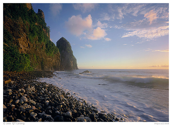
Tutuila Island, National Park of American Samoa, July 2002
American Samoa
Park established 1993
In Polynesia, a paradise-like chain of volcanic mountainous islands clothed in the greenery of old-world tropical rainforest is ringed with steep sea cliffs, glistening beaches, and biologically rich South Pacific coral reefs. The sun rose over the South Pacific, illuminating the cliffs covered with lush vegetation, as the waves filled the air with warm moisture. Remembering a Polynesian myth stating that Creation took place on the Samoan Islands, I imagined I was witnessing the morning of Creation myself.
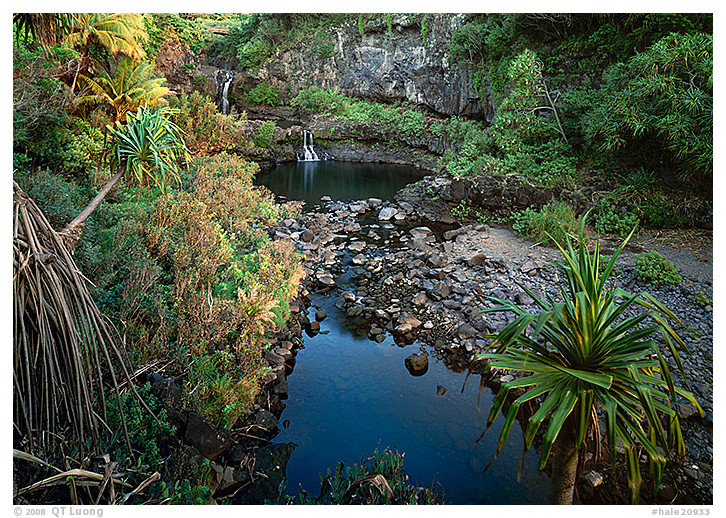
Oheo Stream, Haleakala National Park, January 2001
Hawaii
Park established, 1916
The nearly freezing temperatures and barren lava soil of the 10,000-foot-high Haleakala Crater contrast with the tropical pools and waterfalls found at the ocean’s edge on the island of Maui. The Oheo Gulch on the island’s western side comprises seven freshwater pools connected by rushing waterfalls, considered sacred by Hawaiians, as freshwater is the connection to life. I closed my eyes to take in the fragrance of the tropical vegetation. During the day, swimmers often swarm the pools, but at sunrise, I felt so contented to have this lush paradise to myself.
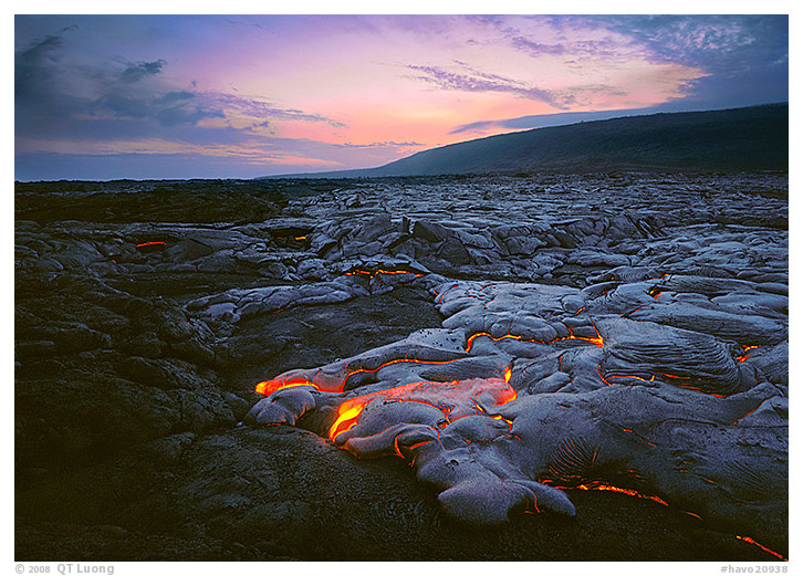
Hawaii Volcanoes National Park, July 2002
Hawaii
Park established 1916
Fiery Kilauea Volcano on the Big Island of Hawaii has been erupting continuously for thirty years, spewing a fluid and slow-moving flow of molten lava. It is so isolated there that evolution has created many life forms found nowhere else on the planet. On my first outing on the live lava fields of Hawaii Volcanoes National Park, I walked for miles on old, hardened lava towards the active flow. During the return hike, I was startled and frightened to see red lava simmering in the dark, shining through cracks right underneath my feet where I thought the ground was solid. On my second visit, a year later, the lava flowed much closer to the road. As I set up the camera a few feet away from the moving flow, the intense heat warmed my face, while I observed new earth being created in front of my eyes.
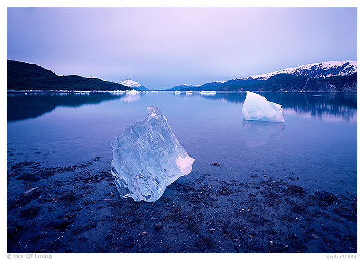
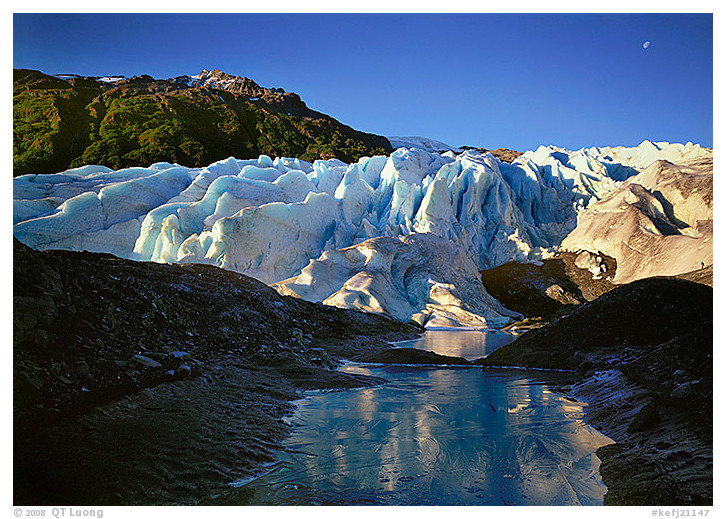
Muir Inlet, Glacier Bay National Park, June 2001
Alaska
Park established 1980
Glacier Bay National Park encompasses fifteen tidewater glaciers that calve icebergs into a vast, Y-shaped marine fjord on the Southeast coast of Alaska. Two hundred years ago, the fjord was still a solid sheet of nearly a mile of ice, but it now includes plant communities ranging from mature spruce and hemlock rainforests, to thinly vegetated areas just recently deglaciated. We reached our destination, a grassy flat near the mouth of McBride Inlet at two in the morning. This was the first day of the ten-day kayak trip. Arnd and I started to paddle at dawn, stopping only to cook dinner on a beach downstream, so the camp would not have bear-attracting smells. After setting up camp, I retreated to my tent, but couldn’t fall asleep. I felt so excited by the possibilities, energized by the lingering half-light of the Alaskan summer. I wandered around the tidal flats until I saw this translucent iceberg lying more than a hundred feet away in the water.
Exit Glacier, Kenai Fjords National Park, September 2000
Alaska
Park established 1980
The Harding Icefield, the largest in North America, gives birth to glaciers that spill into long, steep, rocky fjords whose quiet coves and bays shelter a dynamic marine life from stormy seas. Covering more than half of Kenai Fjords National Park, it gives a sense of the huge ice sheet that covered Alaska during the last ice age. The Exit Glacier originates from the Icefield, spilling down 3,000 feet to a spot that makes it one of the most accessible glaciers anywhere. I strolled on the short trail to the Exit Glacier’s tongue, posted with signs indicating the dates when the ice ended at those locations. The dates I read were so recent that I kept thinking the glacier was retreating right before my eyes.
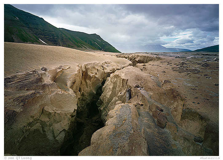
Valley of Ten Thousand Smokes, Katmai National Park, July 2001
Alaska
Park established 1980
During Novarupta’s eruption in 1912, the largest recorded in modern times, a verdant valley became a desert buried in 700 feet of pumice, ash, and vapor-emitting fumaroles, known thereafter as the Valley of Ten Thousand Smokes. This otherworldly environment contrasts with the lakes and rivers that form the largest spawning grounds of sockeye salmon, attracting the largest brown bear population in the world. As my friend Eureka and I were attempting to climb Mt. Katmai in that remote valley, we found ourselves in a whiteout, battered by strong winds, snow, and almost no visibility. Water has carved deep gorges such as the one in the photograph in less than a century, a testimony to the ubiquitous severe weather.
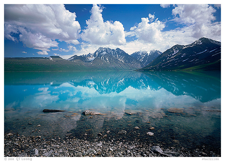
Turquoise Lake, Lake Clark National Park, June 2001
Alaska
Park established 1980
Although it is a mere hour of flight from Anchorage, Lake Clark is the second least visited national park in the country. A diversity of wilderness landscapes beckoning within its relatively small boundaries represent the whole of Alaska: two active volcanoes, the junction of two major mountain ranges with the park’s own rugged Chigmit Range, an eastern coastline with rainforests like those in southeast Alaska, a western plateau with arctic tundra, and clear lakes. After a floatplane drop, we backpacked along the shores of Lake Turquoise, aptly named, for glacial silt colored the lake a surreal, robin-egg blue that was a joy to see.
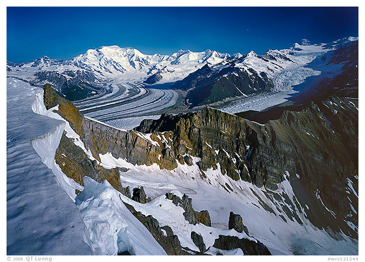
Wrangell-St. Elias National Park, June 2001
Alaska
Park established 1980
In Wrangell-St. Elias National Park, three mountain ranges converge in a park of enormous size – larger than Switzerland – that includes huge braided rivers, 9 of the 16 highest mountains in the United States, and more than 150 glaciers. A dirt road leads to the impressive, abandoned old copper mining town of Kennecott. Walking alone from there, I navigated across the crevasses of Root Glacier, then climbed the steep scree slopes of Mt. Donohue to get a view of the enormous glaciers below the Wrangell Range. However, when I reached the top of Mt. Donohoe in the late afternoon, wildfires had filled the air with haze. I had left my sleeping gear at the base of the mountain, but decided to spend the night on the top anyway. The view in the morning was great.
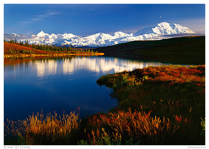
Wonder Lake, Denali National Park, September 2000
Alaska
Park established 1917
As I hiked along the calm shore of Wonder Lake, along the vast expanse graced by wildlife both extraordinarily diverse and visible, including moose, grizzly bears, caribou, Dall sheep, and wolves, the tundra turned crimson. I remembered the two weeks I spent on the icy slopes of Mt. McKinley, seven years earlier, when I solo-climbed the mountain. Even though 30 miles away, the awe-inspiring mountain is so high – at 20,320 feet, the highest in North America – that it looked like it was just behind the hill.
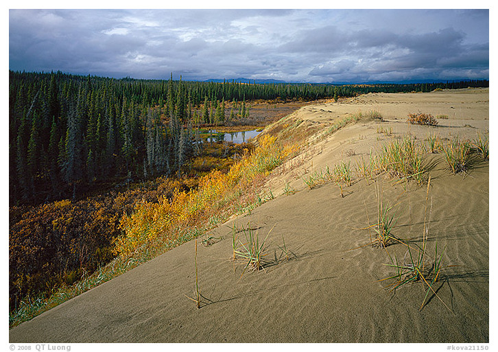
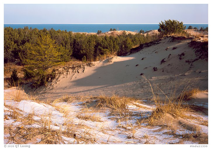
Great Sand Dunes, Kobuk Valley National Park, September 2002
Alaska
Park established 1980
After flying to the small Eskimo village of Ambler with our inflatable canoe, my wife and I paddled for half a week before hiking half a day to reach the Great Kobuk Sand Dunes. These rare and unexpected arctic sand dunes are found in this wide valley, at the northernmost extent of the boreal forest, the centerpiece of a vast ecosystem that includes the half-million caribou of the Western Arctic herd. We initially thought this trip would be a leisurely float down the river, but the sluggish flow, rain and strong headwind made it otherwise. During our week in the least visited of the national parks, we happened upon a few local residents, but never saw any other recreational visitors.
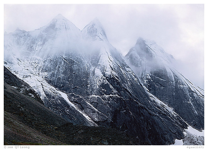
The Maidens, Gates of the Arctic National Park, August 2000
Alaska
Park established 1980
In 2000, I embarked on the trek to the Arrigetch Peaks in Alaska’s Gates of the Arctic National Park, which lies entirely north of the Arctic Circle. Ensconced in the heart of one of the largest and most pristine wilderness areas of the world, with the jagged peaks of the Brooks Range, wild river valleys, and immense expanses of tundra, it was the most remote place I had explored for the purpose of photography. I flew to Fairbanks, then on to tiny Bettles by commuter plane, then to Circle Lake by chartered plane, before backpacking for a couple of days in trailless terrain with more than 65 lbs. of gear. Yet, the Peaks were nowhere to be seen for the first day, hidden by dense, low clouds. When I saw a possible clearing, I gave up breakfast, hurrying to set up the camera with excitement, and waited. Half an hour later, the clouds lifted for five minutes, just enough time for this composition. For the rest of my stay, the clouds did not lift again.
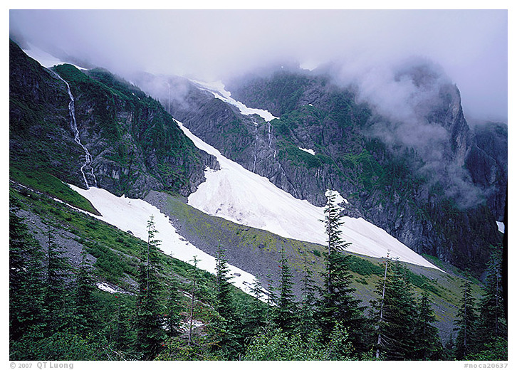
Cascade Pass, North Cascades National Park, July 1998
Washington
Park established 1968
During the two-day climb of Mt. Sahale, a high peak in the center of North Cascades National Park, I eagerly anticipated the vast panorama on the summit, above the clouds. I nevertheless appreciated the view near the trailhead, in the forested valley below the clouds. Intercepted by high, rugged peaks, they give birth to the glaciers, waterfalls, rivers, and lakes that make the mountains so lush.
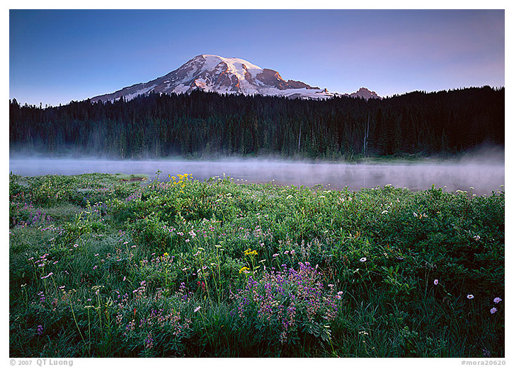
Reflection Lake, Mount Rainier National Park, August 2000
Washington
Park established 1899
Mount Rainier, a massive, symmetrical, ice-capped sleeping volcano visible for over 100 miles, soars above meadows astonishingly dense with wildflowers, calm reflection lakes, and lush, old-growth rainforests. It is so large that it creates its own weather. During its brief summer season, its winter accumulations of snow – one of the largest in America – yield to one of the most beautiful wildflower fields. To catch the first light of sunrise in the summer meant getting up as early as 4 A.M. On my fourth visit, I was rewarded with the sight of fog rising up from Reflection Lakes, as the scent of wildflowers permeated the air.
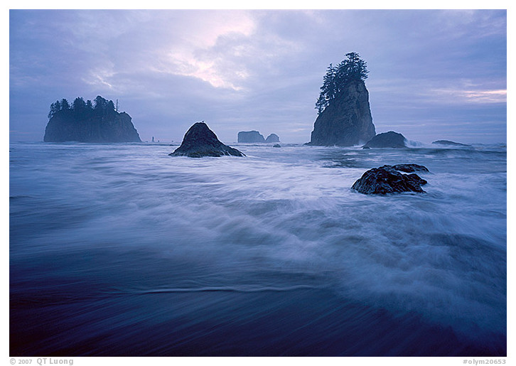
Second Beach, Olympic National Park, August 2004
Washington
Park established June 29, 1938
Water and ice have shaped three ecosystems in this vast wilderness that occupies most of the Olympic Peninsula: a rugged coastline of seastacks and tide pools; a rare, temperate rainforest lush with dense greenery; and mountains capped by numerous thick glaciers. I felt invigorated by the salty mist projected into the air by each wave, as it crashed on the dark, sandy beach. The ocean had lent me some of the strength it displayed when it tore those seastacks, tiny vegetated islets that dot the Pacific Northwest coast, away from the mainland.
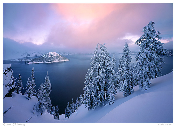
Crater Lake National Park, January 2004
Oregon
Park established 1902
In the seven thousand years since Mount Mazama’s upper cone collapsed into a steep crater during a tremendous eruption, abundant snowmelt has accumulated to form the deepest lake in the country, an impossibly large and beautiful circle of pure, intense blue. I arrived in a snowstorm that obscured the lake from view. Drawn to the pristine blanket of snow on the trees, I started hiking along the rim in snowshoes, hopeful that the storm would weaken. Moments before dark, to my elation, the clouds lifted to reveal the entire extent of the lake as the last light colored the sky.
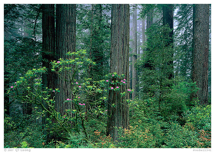
Del Norte, Redwood National Park, May 1998
California
Park established 1968
Walking among the ancient redwood trees, I felt the stillness of the coastal fog that provides nourishment to the tranquil groves of those giants, the earth’s tallest trees. My visit to the park, which follows forty miles of Northern California shoreline, was well- timed, as in the deep darkness of the forest, rhododendron blossoms provided brilliant accents of color.
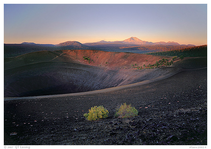
Cinder Cone, Lassen Volcanic National Park, September 2000
California
Park established 1916
Catching my breath from hiking in the dark on soft, volcanic ash and cinder to the summit of the cinder cone, I looked at Lassen Peak in the distance. The volcano had a series of eruptions less than a century ago, creating cinder cones; lava fields; hot springs; hissing, steaming fumaroles; boiling mudpots; and pungent sulfur vents. I meditated about the magnitude of the violent geologic events that shaped that landscape, making it into a real-life dictionary of volcanic features.
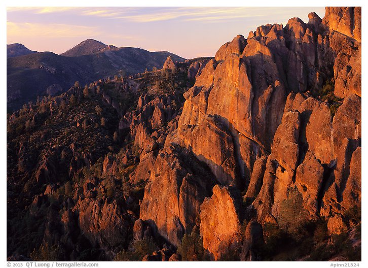
High Peaks, Pinnacles National Park, March 2013
California
Park established 2013
Because it is not traversed by a road, Pinnacles National Park feels larger than its acreage would suggest. Hiking is the only way to reach the most dense section of volcanic monoliths and crags after which the Park is named. I used to rock-climb there years ago, but that day my goal was to create new photographs of our most recently designated National Park with the large format camera. After gaining more than a thousand feet of elevation on the steep chaparral-covered Gabilan Mountains, I arrived just in time to marvel at the first light coloring the High Peaks rock spires orange, as a pair of California condors began to soar in the distance.
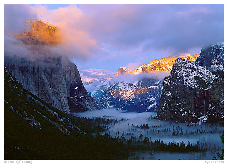
Yosemite National Park, January 2002
California
Park established 1890
Yosemite National Park is the place that drew me to California, the national park that I visited first and most often. Yet it was more than a decade – and hundreds of days spent in the Park – later that I eventually captured, on a winter sunset evening, the image that best sums up the magic and majesty of the valley for me. The Tunnel View is one of my favorite places to view Yosemite Valley. There are few places where you can see such a valley rimmed by sheer granite walls, monoliths, and waterfalls. Although the location is always stunning, on that cold winter evening, I happened to be in the right place at the right time, when the sun appeared from under the storm clouds to set the tops of the cliffs on fire for a brief moment, creating the contrast that I was seeking for this color homage to Ansel Adams.
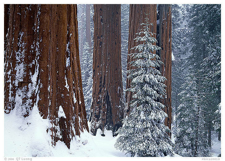
Grant Grove, Kings Canyon National Park, February 1998
California
Park established 1940
Giant sequoias, the largest living things on earth, grow on the western slope of the luminous Sierra Nevada range, cut here by an 8,200-foot-deep canyon, the deepest in the country. The sequoias are about endurance and strength, qualities that I felt would be best expressed in the harsh mountain environment of winter, rather than during the pleasant summer. On my first winter visit, there was no snow on the branches, so the scene did not convey a wintry atmosphere. I drove six hours back home without making a single large- format photograph. I came back again after another snowstorm. However, by the time I arrived in the park, the sun was coming out, and the snow had already started falling from the trees. On the third trip, I came during the peak of the snowstorm. Although I snowshoed around the grove for hours in full winter mountaineering gear, evaluating numerous compositions, I ended up with only three different large-format photographs, taken during brief lulls when the wind was not blowing snowflakes into the camera lens.
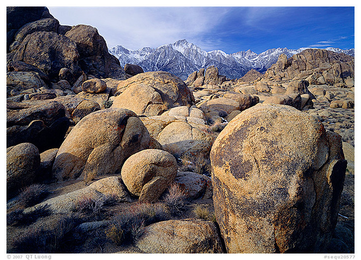
Alabama Hills, Sequoia National Park, February 1997
California
Park established 1890
Groves of giant sequoias grow on the gently sloping west side of the Sierra Nevada range. Although Mt. Whitney’s 14,495-foot peak, the highest in the continental United States, is hidden from the roads of Sequoia National Park, it towers above the Owens Valley in the east. I wandered there the whole morning along the sea of golden granite boulders rising up from the desert floor, their rounded contours contrasting with the snowy ridges of the Sierra Nevada. More than 150 movies used this location as an archetypal “rugged” Western environment.
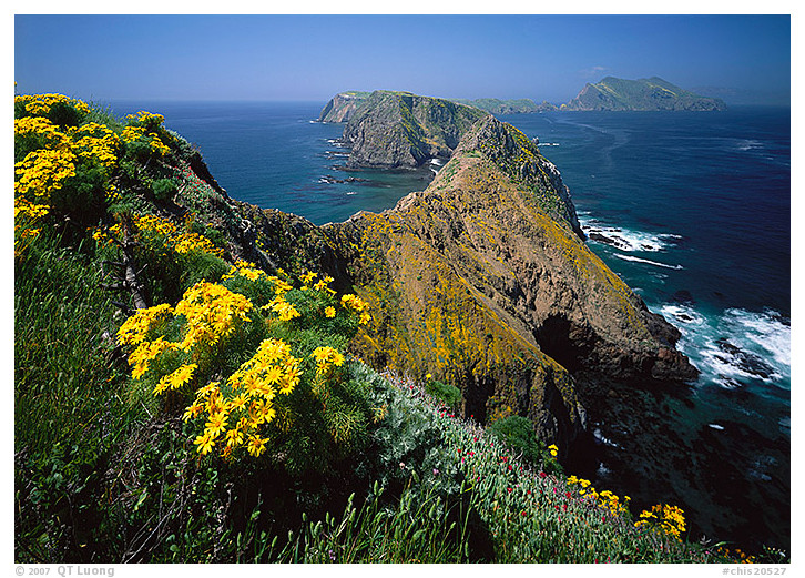
Inspiration Point, Channel Islands National Park, April 2000
California
Park established 1980
Channel Islands National Park’s five craggy islands, isolated from the mainland by turbulent ocean forces, are home to extensive marine mammal rookeries, nesting seabirds colonies, and many plant species found nowhere else. The aptly named Inspiration Point presents the most spectacular view on the Pacific Coast. For a short time in the spring, the endemic giant coreopsis, with its bright yellow flowers, highlights the chain of Anacapa Islands. Turning around, you can see the mainland coast, close, but a world apart. For an entire morning, I was captivated by the dynamic spectacle of waves and soaring seagulls below my high vantage point.
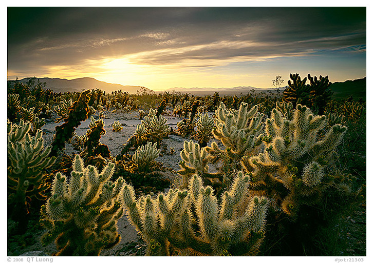
Cholla Cactus Garden, Joshua Tree National Park, April 2000
California
Park established 1994
Joshua trees and granite boulders characterize the windy high Mojave Desert, while at the Colorado Desert’s lower elevations, cactus and native California palm trees thrive among sandy washes occasionally flooded by unpredictable torrents. I was not sure if I inadvertently brushed against a cholla cactus, or if the piece jumped at me while I was looking for a good viewpoint in Joshua Tree National Park during the predawn darkness, but the result was that I couldn’t dislodge it with my bare hand for fear of getting my fingers stuck as well. A beautiful sunrise below the clouds kept me in the Cholla Cactus Garden, with a cactus clenching onto my behind, until the light was well over. I then strolled back to the car to tease the spiny thing out with pliers.
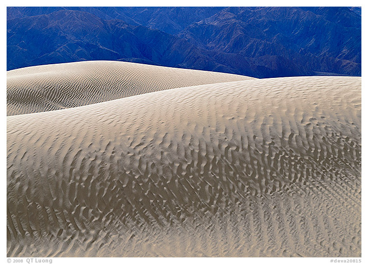
Mesquite Sand Dunes, Death Valley National Park, December 1997
California
Park established 1994
In 1993, on my first visit to Death Valley, following Yosemite and Denali, I realized how much of nature’s variety was showcased in the national park system as a whole. Death Valley is the hottest and driest area in the country, a vast and trying place of desert extremes, ranging from the lowest point in the Western Hemisphere to tall snow-capped mountains. Many geological wonders – vast sand dunes, one of the largest salt pans on earth, and rocks moving mysteriously on a dry lake bed – highlight it. Growing up in France, I had never seen deserts before. The sight of the dunes set in the vast valley astonished me, as did the distances there. What at first promised to be a short stroll took an hour of trudging in the sand. After visiting the dunes many times, I strived to challenge the notion that no good landscape photograph can be taken there at midday.
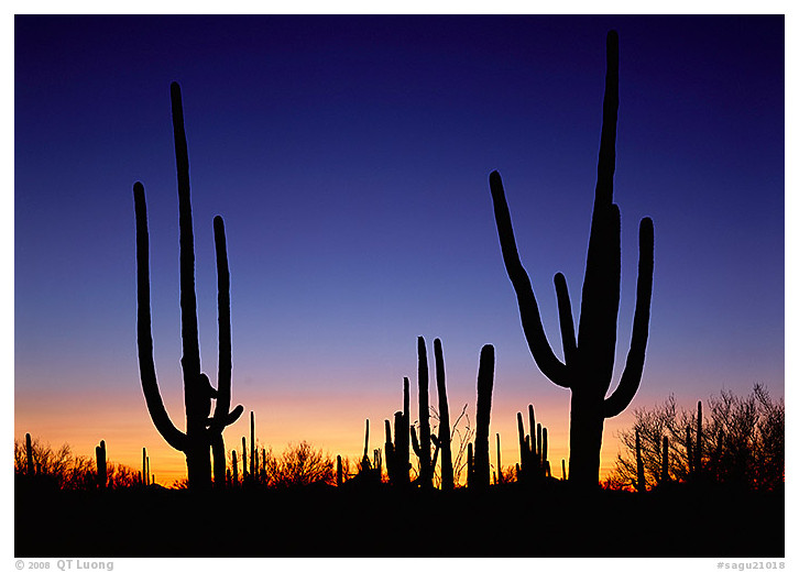
Saguaro National Park, April 2000
Arizona
Park established 1994
The heat and aridity overwhelmed me during the day, but as the night fell, the Saguaro National Park’s desert became a place of quiet serenity. Before fading into the dark, the giant, 30-foot-high, saguaro cacti, found only in the Sonoran Desert, where they form forests on valleys and rocky mountain slopes, stood in contrast against the clear sky.
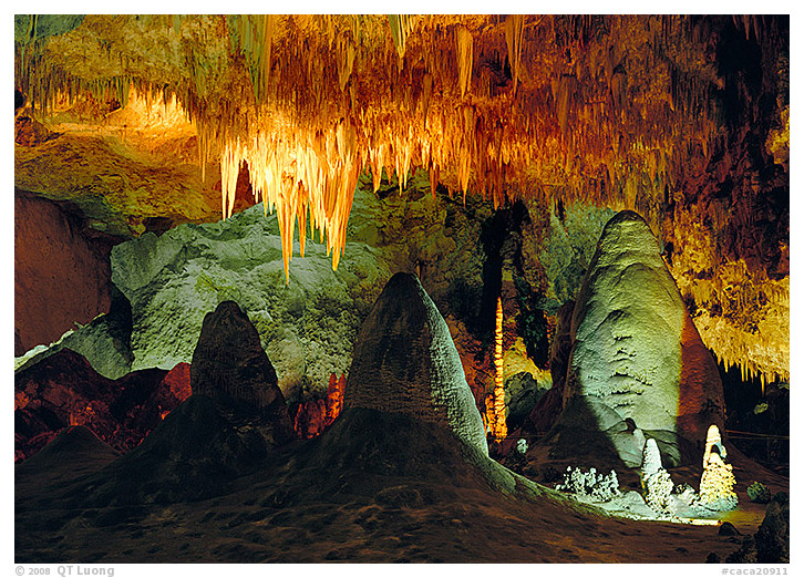
Carlsbad Caverns National Park, May 1997
New Mexico
Park established 1930
Of all the caves in the national parks, Carlsbad Caverns remains my favorite because it combines some of the world’s largest underground chambers, with decorations of great beauty and variety that adorn a complex, subterranean array. Unlike other caves with guided tours, I can explore here at my own pace and photograph with a tripod: the only way to obtain good photos, since exposures for images such as this one can take up to half an hour.
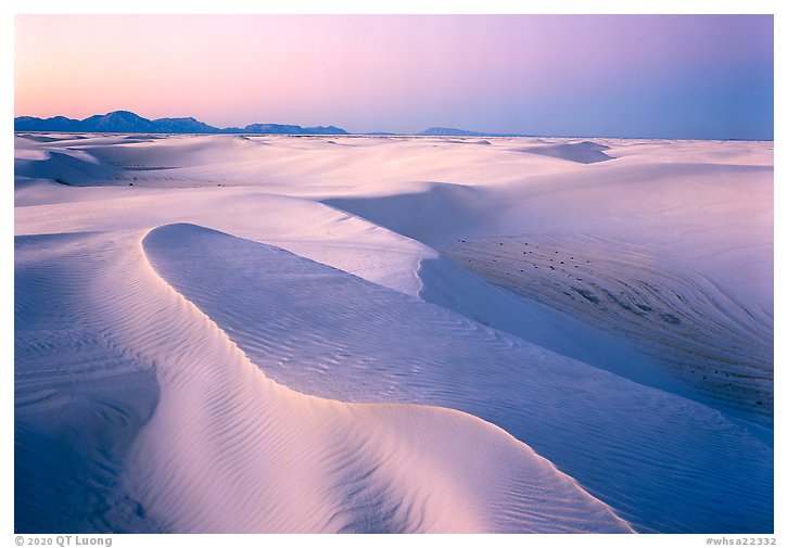
White Sands National Park, December 2019
New Mexico
Park established 2019
In the heart of the Tularosa basin, parts of the Chihuahuan desert are covered by rare glistening gypsum dunes extending on a far larger area than anywhere else on earth. On the evening of Friday, December 20, 2019, White Sands National Monument was redesignated White Sands National Park. Having obtained a backcountry camping permit despite the subfreezing temperatures, I was one of the few visitors left in the park when it closed at sunset. At twilight, a long exposure on film intensified the magical colors for what was likely the first large-format photograph made in the brand-new national park.
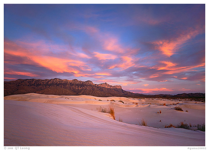
Guadalupe Mountains National Park, November 2000
Texas
Park established 1972
I spent the afternoon in the hot Texas desert. As the temperature cooled down, I put my shoes back on, fine gypsum sand still sticking to my feet. Blinding during the day, the white sand dunes now reflected the vivid sunset color of the sky. One of the largest and most ancient fossil limestone reefs, the Guadalupe Mountains rose abruptly over the Chihuahuan desert dunes, sheltering in their canyons a complex assemblage of thorny and deciduous plants, and catching the last glow of the day.
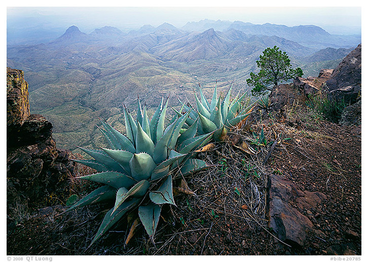
South Rim, Big Bend National Park, November 2000
Texas
Park established 1944
Quang-Tuan Luong Delimited by spectacular canyons of the great bend of the Rio Grande River, the Chisos, an entire, contiguous mountain range protected by Big Bend National Park, dominate a surprising desert often punctuated by resilient flowers. After hiking up to the top of the Chisos, I slept under a large pinion pine. The next morning, I wandered along the South Rim, admiring the panoramic view of mountains below. I discovered with delight several beautiful, giant agaves, a typical plant of the Chihuahuan desert. The dusty, blue leaves harmonized in the soft morning light, adding a lively focal point to this composition.
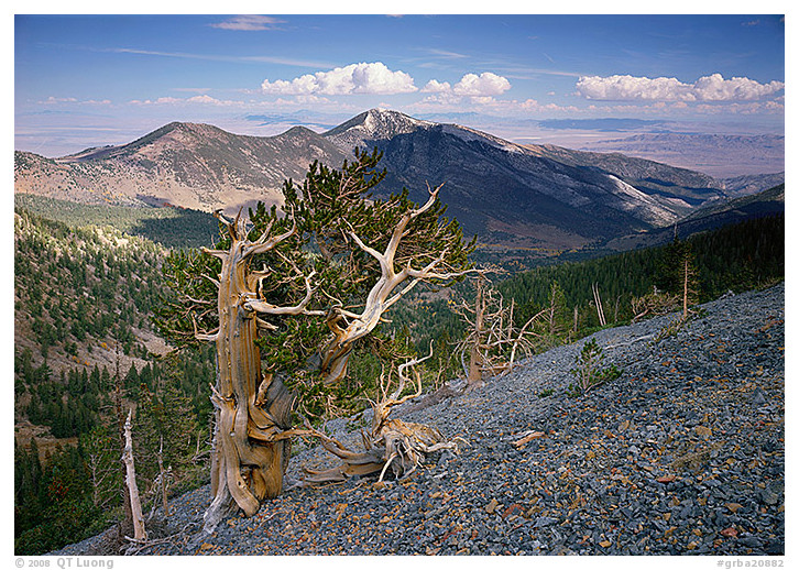
Mt. Washington, Great Basin National Park, October 2003
Nevada
Park established 1986
High above the Great Basin Desert in Nevada, the South Snake Range forms a vegetated island. An isolated, obscure, long, rough unpaved road leads to the summit of Mt. Washington from the backside. Groves of bristlecone pine trees grow nearby, clinging to rocky ridges and cirques, while below, limestone rock has been carved into a large arch and the intricately decorated Lehman Caves. The oldest living things on earth, those trees were already saplings before the Egyptians built the pyramids. Right on the summit, I got a flat tire. During the two days I spent on Mt .Washington, I didn’t see any other soul; however, I managed to find the tools and spare tire for my borrowed car and return to civilization on my own.
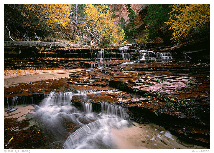
North Creek, Zion National Park, October 2003
Utah
Park established 1919
In Zion National Park, vertical cream, pink, and red sandstone cliffs form citadels of stone that tower above deep, narrow canyons carved by streams, creating an oasis of life in the desert. During my visit, flowing water, autumn colors and redrock canyons combined to create such magical scenes around each corner of the Left Fork of the North Creek. Kayenta sandstone layers created cascades all over the terraces. Although I started the eight-mile hike at sunrise, I got back to my car well after dark, with boots soaking wet from creek hopping.
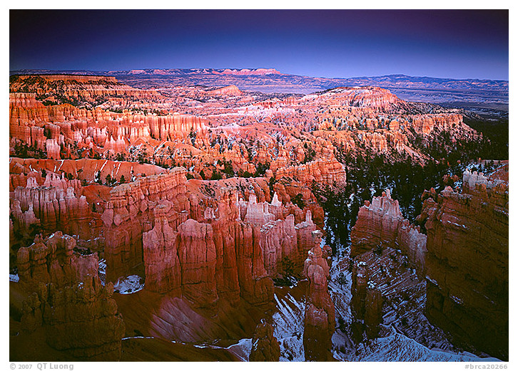
Sunset Point, Bryce Canyon National Park, November 1996
Utah
Park established 1928
Bryce Canyon amphitheater, populated with innumerable brightly colored, free-standing hoodoos, spires, fluted walls, and pinnacles, forms one of the most astonishing landscapes I’ve seen. The scenery breathed the solemn air of a medieval city, silenced by the abrasion of time. Most people photograph the east-facing, horseshoe-shaped amphitheater along the edge of the Paunsaugunt Plateau at sunrise; however, dusk offers an even lighting that reveals the range of bright colors.
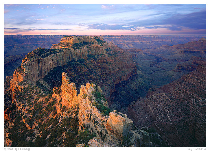
Cape Royal, Grand Canyon National Park, October 2003
Arizona
Park established 1919
Looking into Grand Canyon National Park at sunrise from Cape Royal, I tried to map out the backcountry route I would travel in a few hours to reach the Colorado River, more than 5,000 feet below. I couldn’t even see the river, lost in the vastness of the Grand Canyon. The mile-deep canyon, exposed by forces of erosion, affords vistas from its rim, where space and time take on geological proportions that overwhelm our senses. No other place holds the power to make you feel so insignificant in the greater scheme of things like this giant fissure.
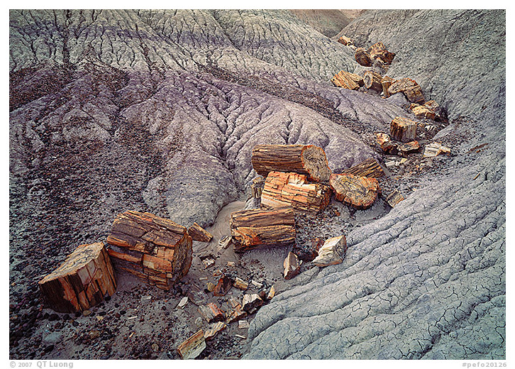
Blue Mesa, Petrified Forest National Park, November 1996
Arizona
Park established December 9, 1962
Had not they been announced by the name of the park, the petrified logs would have appeared out of place in that treeless ancient, badlands of the Painted Desert. As I took a closer look, I marveled at the magic that had, cell by cell, transformed prehistoric logs into brilliantly colored stone, often veined with quartz blossoms.
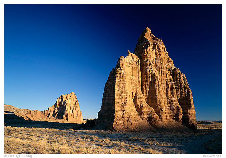
Cathedral Valley, Capitol Reef National Park, November 1997
Utah
Park established 1971
Little-known Capitol Reef National Park offers more variety of rock formations than any other national park of the Colorado Plateau. Sheer monoliths, domes, canyons, and arches highlight the Waterpocket Fold, a 100-mile-long wrinkle on the earth’s crust. This uplift of sandstone cliffs with colored horizontal layers presents all the landforms and geological processes typical of the Colorado Plateau. My most memorable visit has been to the Cathedral Valley, a majestic landscape of stone and silence. Adorned by huge monoliths with names such as Temple of the Sun and Temple of the Moon, the place is so remote that during a whole day of driving its primitive roads, I hardly encountered any other vehicles.
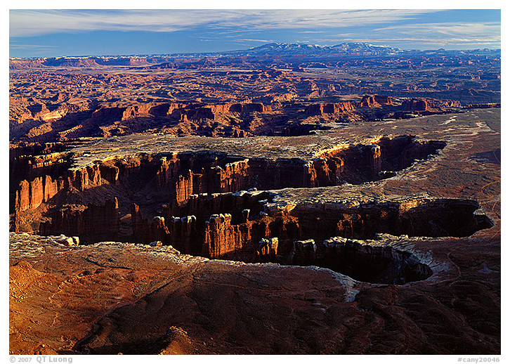
Grand View Point, Canyonlands National Park, November 1996
Utah
Park established 1964
Canyonlands includes some of the most remote and inaccessible terrain in the lower 48 states, with paved roads leading only to overlooks. Small and large canyons, complex networks of eroded passageways, mesas, buttes, arches, pinnacles, and prehistoric ruins form this silent and lonely wilderness of rock centered on the junction of the Colorado and Green River. Contemplating it from the edge of a high plateau aptly named Island in the Sky, I began to make more sense of this overwhelming tangled expanse of rock as I scanned the vast distance to trace the outlines of the various canyons that make up the landscape.
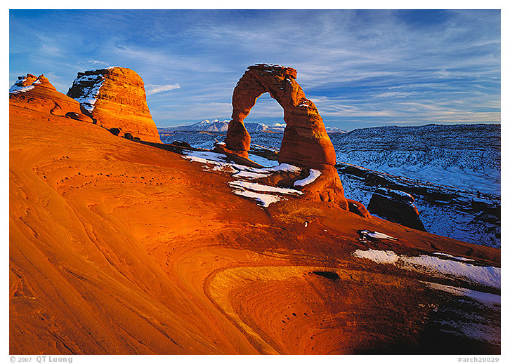
Delicate Arch, Arches National Park, November 1996
Utah
Park established 1971
In this national park, erosion has sculpted the entrada and Navajo sandstone into a whimsical rock garden that includes the largest collection of natural arches on earth. What distinguishes Delicate Arch, Utah’s state symbol, among them is its graceful shape, curving above a slickrock basin, acting as a perfect natural frame for the La Sal Mountains backdrop. On that frigid, late November evening, other hikers took a quick look before heading back. As I stood in the biting wind, the last light intensified the colors of the red sandstone, contrasting it to the blue hues of the snow-covered slope. By the time I returned to the parking lot, everybody had left; the temperature had dropped to single digits; my car battery had died. I relied on my expedition-grade sleeping bag to keep me warm for the night.
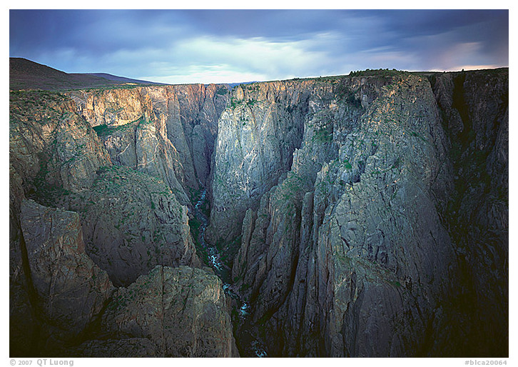
Narrows, Black Canyon of the Gunnison National Park, May 2001
Colorado
Park established 1999
The Black Canyon of the Gunnison is unmatched in North America for its combination of startling, 2,700-foot depths and a narrow opening – only 1,000 feet at its narrowest. After a long descent, I reached the canyon’s bottom. I was pulling out my camera when my tripod, balanced on slick rocks, suddenly tipped over, swallowed by raging waters. I looked on with dismay, silently saying farewell to my three-legged-mistress, as my wife not-so-fondly calls my tripod. Unable to photograph anymore with the large-format camera, I scrambled up the steep gully. I later photographed the near-vertical, marbled walls of this canyon from an overlook using my back-up tripod, as spots of sunset light filtered from a dark sky.
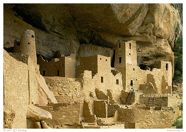
Cliff Palace, Mesa Verde National Park, May 2001
Colorado
Park established 1906
Set in high mesas, the largest, best preserved, and most notable ancient Pueblo cliff dwellings in the country bear silent witness to the accomplishments of the most developed civilization in ancient America. Walking among the ruins of Cliff Palace, I kept wondering why all of a sudden these people left their homes about A.D. 1300, never to return again.
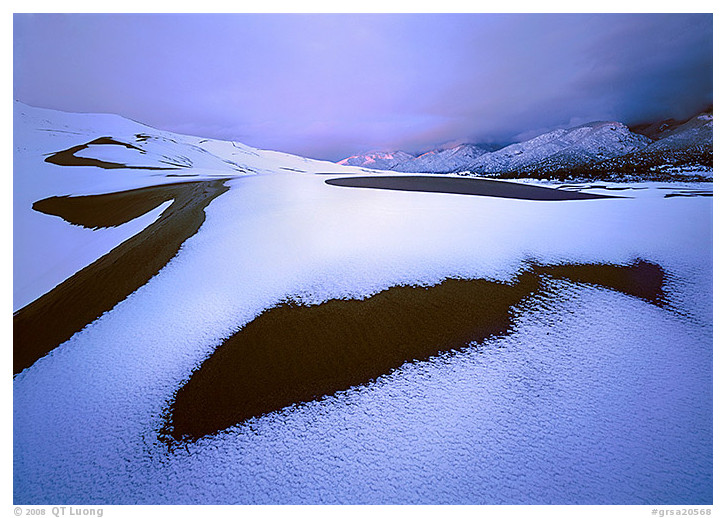
Great Sand Dunes National Park, May 2001
Colorado
Park established 2004
When the alarm rang on this morning of May, I could not believe that two inches of snow had covered the car. Past the shock, the prospect of witnessing a familiar landscape – the continent’s tallest dunes of sagebrush desert sands deposited in the shadow of high mountains of the Rocky range – in unusual conditions filled me with anticipation. The alternating patches of snow and uncovered sand transformed the dunes even more than I had hoped for. Sunrise illuminated the Sangre de Cristo Mountains for a fleeting instant. Later in the day, as the clouds disappeared, the sun promptly melted the snow. I was glad to capture the transient meeting of snow and sand on this rare occasion.
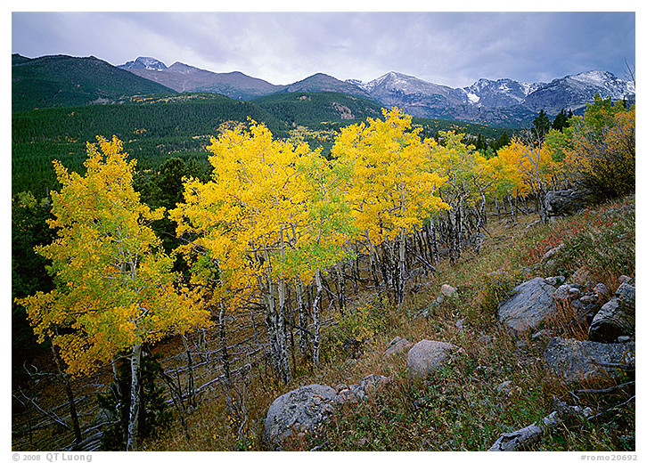
Glacier Basin, Rocky Mountain National Park, October 1998
Colorado
Park established 1915
All the mountain life zones of the Rockies, from dense forests to wildflower meadows and alpine tundra, are easily accessible through Trail Ridge Road, which quickly gains a mile in elevation to cross the Continental Divide. As a storm approached, I rushed down the mountain, not wanting to be caught above tree line. On a bend of the trail, a stand of aspens stopped me in my tracks. I waited for the lull before the rain to make an image, so that each of the bright yellow leaves would be rendered with sharp detail. I made it back soaking wet, but satisfied.
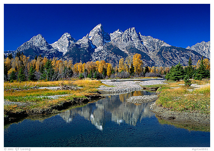
Schwabacher Landing, Grand Teton National Park, September 1996
Wyoming
Park established 1929
Among all mountains in America, the Grand Tetons – rocky, jagged, and abruptly rising seven thousand feet above the Snake River, piedmont lakes, and the sagebrush-covered valley of Jackson Hole – remind me the most of the Alps, on the high peaks where I had my first life-changing wilderness experiences that inspired me to become a photographer. Although witnessing the first light of sunrise at this spot was an enjoyable experience, my intuition led me to return at midday. The midday photograph turned out to be my favorite.
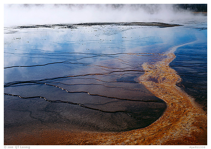
Great Prismatic Springs, Yellowstone National Park, September
1996
Wyoming
Park established 1872
Yellowstone, the first national park in the world, was designated to protect the majority of the earth’s geysers, as well as other thermal wonders that make up an otherworldly landscape. Its vast size includes mountain ranges, lakes, waterfalls, the Grand Canyon of the Yellowstone. It is also the only place in the continental United States where every species of native large mammal, including the last free-ranging bison herd, survives today. Approaching the Great Prismatic Springs, the largest hot springs in the country, I could see only thick steam rising from a distance. As I walked on the boardwalk, I became amazed by the vivid gradient of colors, created by different bacteria that thrive at different temperatures.
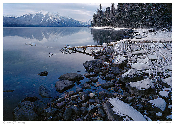
Lake McDonald, Glacier National Park, November 1995
Montana
Park established 1910
Here in Montana, the glaciers that carved limestone peaks into steep faces are still present in large numbers, although in diminutive sizes, feeding cascading waterfalls, glistening lakes, and wildflower alpine meadows. It is one of the largest and most intact ecosystems on the continent. When I arrived, winter had just closed the busy Going-to-the-Sun Road, one of the most spectacular drives in North America. A few steps from the road, a great calm enveloped the shores of Lake McDonald, as if all motion in the landscape had been frozen. On that gray day, no rushing was required to catch the light. I could contemplate the moment as I set up the camera slower than usual because of the thick gloves I used to protect my hands from the intense cold.
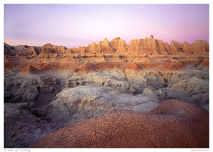
Cedar Pass, Badlands National Park, October 1998
South Dakota
Park established 1978
As the light of dawn painted the sky a delicate pastel, I stepped gingerly over the cracked earth, not wanting to even leave footprints, although I knew that the bizarre erosion architecture surrounding me would soon succumb to the creative and destructive forces of water. The layers of mud sediments here, one of the largest protected sections of the Great Plains prairie, have been eroded into a strange terrain of countless gullies and walls that contains the world’s richest fossil beds from the Oligocene epoch, some 30 million years ago.
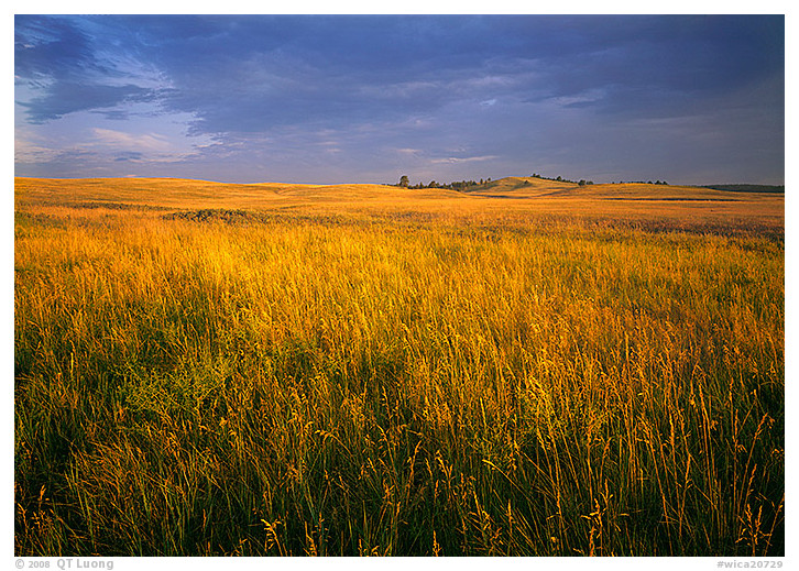
Bison Flats, Wind Cave National Park, July 2003
South Dakota
Park established 1903
Beneath Wind Cave National Park’s prairies and ponderosa-pine covered rolling hills lies a long, limestone cave decorated by boxwork, an unusual formation composed of thin, calcite fins resembling honeycombs. After the last night’s rain, the grasses exuded a fresh, damp smell that beckoned me to linger longer to take a more attentive look. As the low sun highlighted the texture of the prairie, I identified a diverse blend of tall and short grass species. One of the last remnants of the original prairie that covered most of the continent, this place wouldn’t have been preserved if it weren’t for the network of caves that lies underneath.
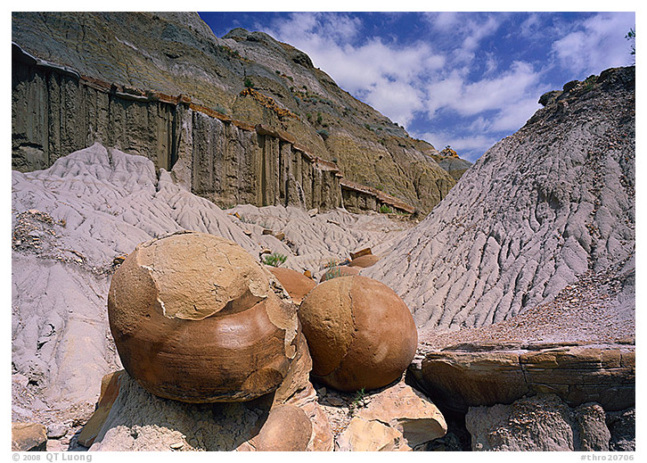
North Unit, Theodore Roosevelt National Park, July 2003
North Dakota
Park established 1978
Theodore Roosevelt developed the character that allowed him to be a great president – one who accomplished so much for the national parks – while hunting in the rugged, colorful landscape of North Dakota. As I wandered the same landscape, my interest was in comparing it with South Dakota’s Badlands National Park. I found more geological variety here, with formations such as petrified trees, caprocks, and large, perfectly shaped cannonball concretions.
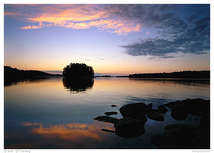
Kabetogama Lake, Voyageurs National Park, September 2001
Minnesota
Park established 1975
To explore Voyageurs National Park, an archipelago of north woods islands, you have to travel the narrow waterways by boat, just like the French-Canadian fur traders who paddled their birchbark canoes from this area all the way to the Atlantic coast. Prior to renting a small motorboat on this trip, I had no experience using one. On the tranquil evening when I took this photograph, the water was still as a mirror. However, the next day, a storm developed on the lake. The situation became increasingly alarming, as the fuel ran out and the boat began to bob up and down, out of control. I found a spare fuel tank left in the boat, managed to swap it, arriving back to the dock barely before dark.
Indiana Dunes National Park, February 2019
Indiana
Park established 2019
Beyond the 15 miles of beaches and sand dunes lining the southern shore of Lake Michigan, lies a biologically diverse tapestry of prairies, rare oak savannas, wetlands, and forests. Given the heavy industrialization of the park’s surroundings, I was struck by how it exemplified the struggle to balance development and conservation, and how easily areas like that could quickly disappear.
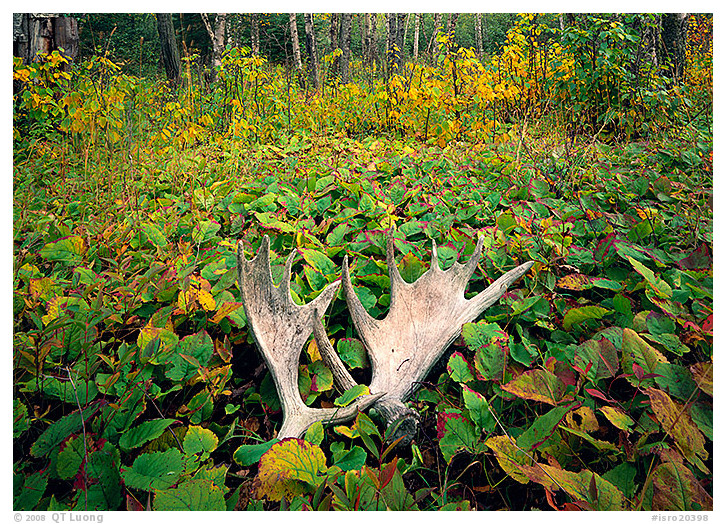
Windego, Isle Royale National Park, September 1997
Michigan
Park established 1940
During my first visit to Isle Royale, an isolated, glacier-smoothed and polished archipelago in Lake Superior, a storm developed. As the ferry would not attempt the dangerous crossing, I was stranded on the wild island for two more days. Afraid of missing a sudden departure, I limited my explorations to the nearby forest around Windego. I had first heard of Isle Royale through the studies of its dynamic populations of wolves and moose and their predator-prey interactions. I was satisfied to find evidence of the moose there: a pair of antlers that had been shed in a previous year.
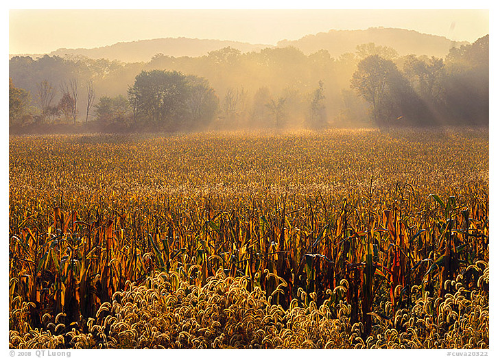
Cuyahoga Valley National Park, October 2001
Ohio
Park established 2000
Cuyahoga Valley National Park encompasses wooded ravines and gentle rural landscapes that follow the winding Cuyahoga River, stretching along the historic Ohio and Erie Canal. At first, expecting the traditional terrain of a national park, I was disappointed to find an area criss-crossed by roads, city parks, attractions, private homes, and agricultural lands. After a few days, however, I found the mix of manmade features and pockets of natural beauty appealing. I became hopeful that a harmony between man and nature could still be found, even between two sprawling cities such as Cleveland and Akron.
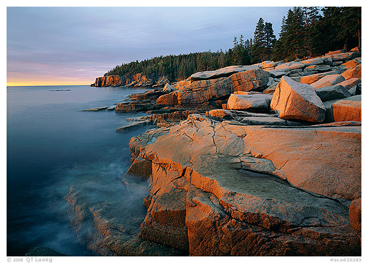
Otter Point, Acadia National Park, October 1997
Maine
Park established 1919
As I got ready – an hour too early – to photograph sunrise, I sat on a granite slab on Mount Desert Island, contemplating the dynamic meeting of the ocean and the tallest mountains on the U.S. Atlantic coast, where old glaciers have created a rugged coastline of numerous inlets and coves encircling domes and lakes. Despite its relentless attack, the ocean has not yet managed to smooth out the jagged pink granite edges of this rocky sentinel. When the sun eventually rose, the first few rays to meet the continent highlighted the entire ragged coastline for a brief moment.
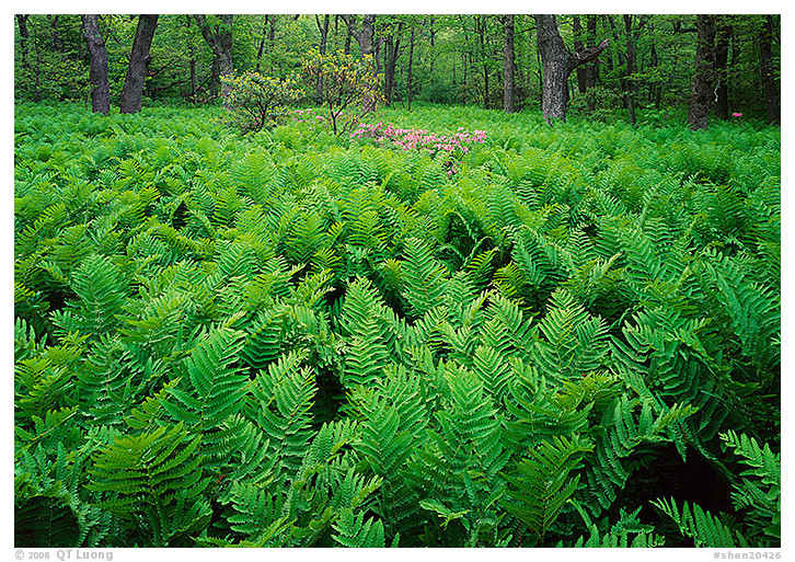
Shenandoah National Park, June 1997
Virginia
Park established 1935
Great vistas abound along the scenic Skyline drive that follows the crest of the Blue Ridge Mountains for more than a hundred miles, while on the slopes beneath, cascades and waterfalls animate a diverse hardwood forest. What makes me feel connected to the living world, however, are the intimate forest views provided by hiking. A sense of happiness filled me the moment I stumbled upon a clearing covered by a luxuriant growth of ferns, the tenderest green surrounding cheerful pink flowers.
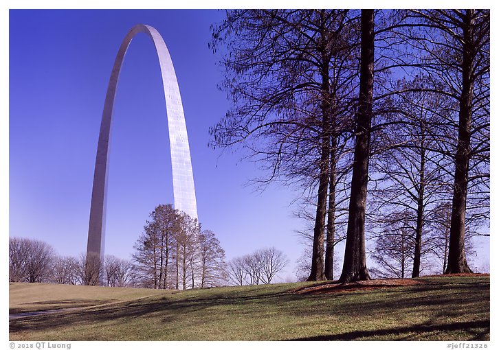
Gateway Arch National Park, March 2018
Missouri
Park established 2018
The inspiring 630-foot Gateway Arch, a masterpiece of 20th-century Modern design together with its landscaped grounds, commemorates Thomas Jefferson and St Louis’s role in the westward expansion of the United States. Expecting just another monument, I was awed by Gateway Arch’s size and purity of form. Maybe because its beauty draws from mathematics and the way it constantly changes with the light, as a former scientist turned photographer, I found it very moving. I have visited the other iconic monuments in America, and to me, the hope and transcendent power of the arch surpassed them all.
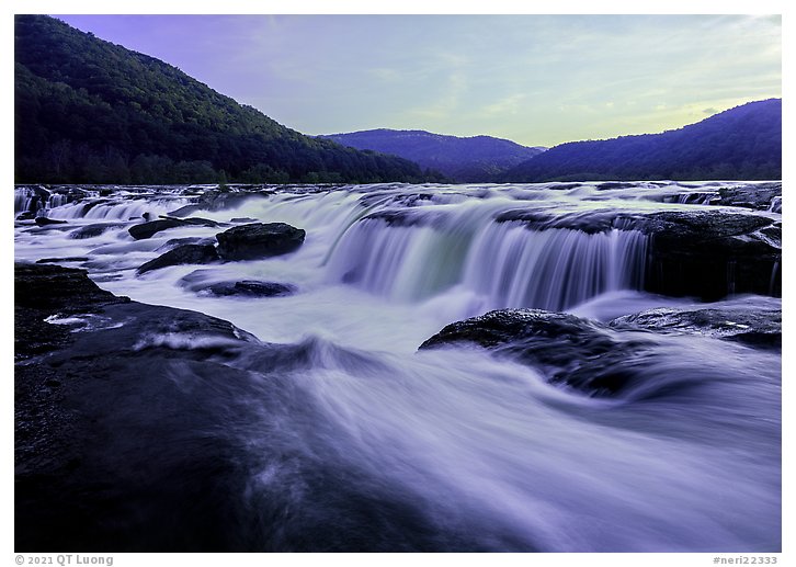
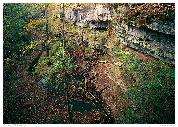
Sandstone Falls, New River Gorge National Park, May 2021
Missouri
Park established 2020
The longest and deepest canyon in the Appalachian Mountains, the New River Gorge has been carved by a river that is, despite its name, one of the oldest in the world. I had heard of the area as an East Coast outdoor activities hub. However, I was surprised to discover a rich array of flora and wildlife, and so many historical structures that the place often feels like an open-air museum of America’s early industrial days. Sandstone Falls marks the transition from a broad stream into a narrow whitewater river roaring through a V-shaped gorge. After crossing three streams, I stood in awe at the edge of the all-encompassing water raging from a 1,500-foot-wide waterfall.
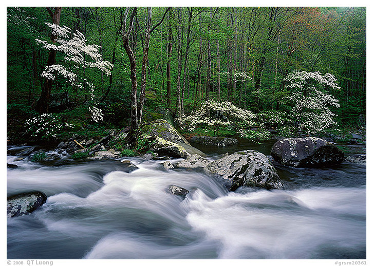
Middle Prong of the Little River, Great Smoky Mountains National
Park, April 2003
Tennessee
Park established 1934
From the ridges of the highest peaks of the Southern Appalachian mountains, clear streams flow into one of the most varied deciduous forests on earth. Vapors there lay a diffuse haze that helps ensure ideal growing conditions for more than 100,000 plant species. I had scouted this scene the day before, but the delicate dogwood blossoms kept moving under a small breeze, so they appeared as blurs with a multi-second exposure time. When I returned early the next morning, the wind had stopped and, except for the murmuring stream, everything lay peacefully still. As if infected by the contagious stillness, I just sat there, soaking in the peace for a very long moment after clicking the shutter.
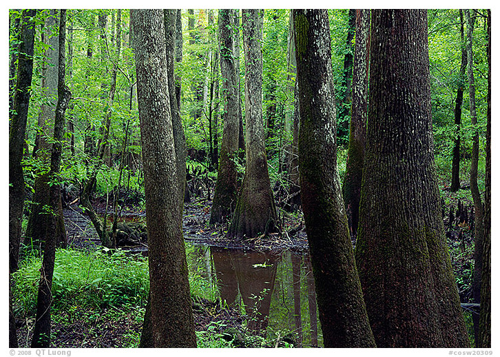
Congaree National Park, June 2000
South Carolina
Park established 2003
In South Carolina’s Congaree National Park, I walked the unusually long boardwalk loop trail above the primeval swamp. The tranquility of this last major, old-growth floodplain forest on the continent absorbed me. Massive trees grew out of the water. When I craned my neck to follow their trunks towards the sky, the canopy surprised me by its height. I learned later that many of the trees in the park are record-size specimens.
Mammoth Cave National Park, May 2001
Kentucky
Park established 1941
At over 350 miles in length, three times longer than any other mapped cave on the earth, Mammoth Cave is a real underground wonderland. However, during the ranger-guided tours, I got only a few photos — none with the large-format camera — due to tripod restrictions. Afterwards, as I enjoyed the freedom of exploring the forested landscape of river valleys, I found in the sinkholes and limestone cliffs subtle clues that a vast cave system lies underneath.
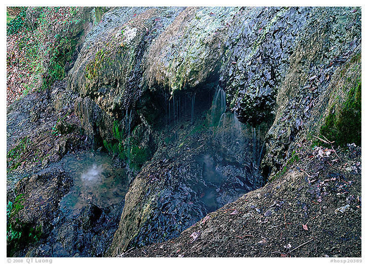
Hot Springs National Park, December 1997
Arkansas
Park established 1921
Here in Arkansas, dozens of steaming hot springs nestled in the forested hills of the Ouachita Mountains supply soothing waters for eight palatial bathhouses lined up on a historic row. I spent most of the cold, rainy day inside the bathhouses, sampling the naturally heated water. Taking advantage of a weather break, I ventured on the hill above the historic district, seeking the source of this simple and priceless gift of such comforting water.
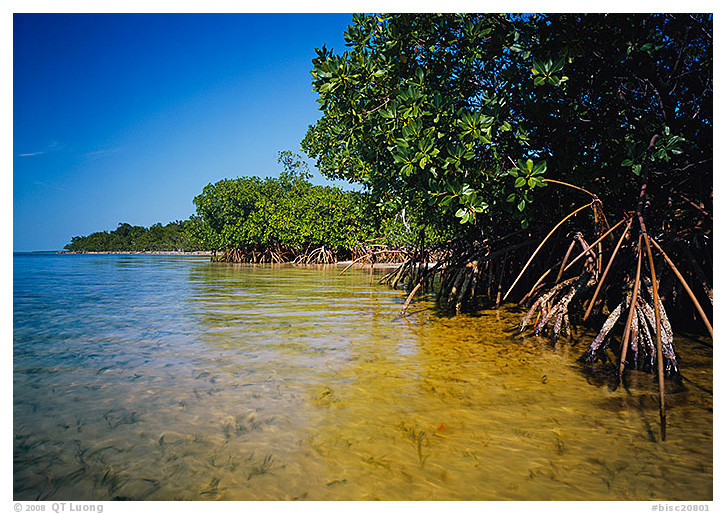
Elliott Key, Biscayne National Park, February 2002
Florida
Park established 1980
Created by an accumulation of coral thriving in the stunning northernmost reef in North America, the Keys act as tropical barrier islands, allowing the sheltered bay to be lined with the longest mangrove shoreline on the East Coast. As I walked on the soft sandy floor, towing behind me a small, inflatable boat for my camera bag, I felt the pleasurable caress of the warm, waist-deep water, the brilliant sun, the gentle breeze. The place gently embraced me like an idle lullaby.
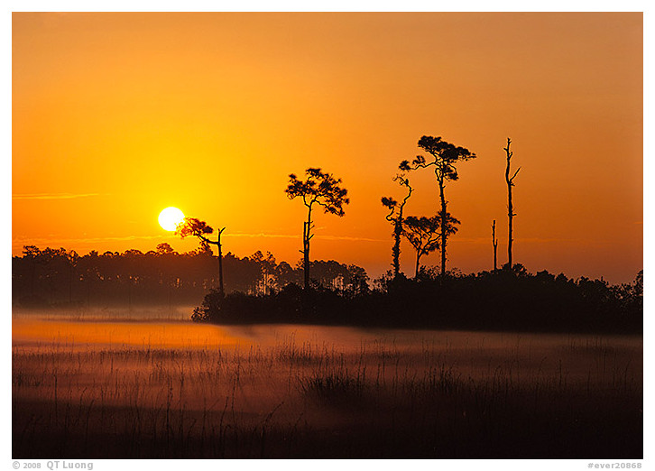
Everglades National Park, February 2002
Florida
Park established 1947
The Everglades is earth’s largest marshland, a fragile, subtropical wilderness where a fifty-mile-wide freshwater river flows imperceptibly towards the saltwater mangrove forest that fringes Florida Bay. As the sun rose over a prairie of sawgrass, I could hear the songs of countless birds as they were preparing to take off for the day. The thin layer of fog that hovered above dissipated at a fast pace. The sun revealed a seemingly wild, desolated place, yet this park is throbbing with life. I could sense millions of birds and insects – and maybe a few yawning alligators – awakening from their slumber.
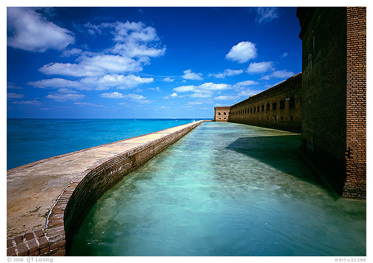
Dry Tortugas National Park, February 2002
Florida
Park established 1992
Dry Tortugas National Park, 70 miles off Key West, Florida, is an underwater park with seven diminutive islets teeming with huge bird colonies and turtles. Fort Jefferson, the “Gibraltar of the Gulf,” takes all the surface of the largest islet. A day after I took a delightful stroll on the narrow seawall suspended above turquoise waters rich with coral reefs, a tropical storm moved in. I found refuge from the strong winds that were shaking my tent inside the unlikely structure, the largest brick building in the Western Hemisphere, made with 6 million handmade bricks. Like Atlantis rising out of water, the place possesses a powerful surrealistic appeal.
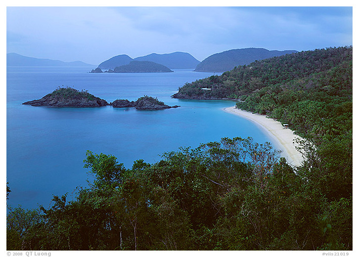
Trunk Bay, Virgin Islands National Park, June 2000
U.S. Virgin Islands
Park established 1956
Most of St. John Island is a laid-back, tropical, Caribbean paradise. The pearl-white beach was too inviting for me not to relax, swimming in the turquoise bay full of coral reefs, although I still toted an underwater camera. As the day drew to a close, the beachgoers left the beach deserted. I climbed back on the surrounding steep verdant hills to capture this idyllic scene.